Victoria – Day 17

Today was our last full day in Victoria and from my perspective, we are exiting with a winning event. – Whale watching.  For those who know me, I have said that salt water runs in my veins.  The one thing I love more than anything is the ocean.  So while I had a fantastic time in the gardens yesterday, this was my day – on a boat on the water.  I have done whale watching before in Alaska, and it is hit or miss.  Well, not in Victoria.
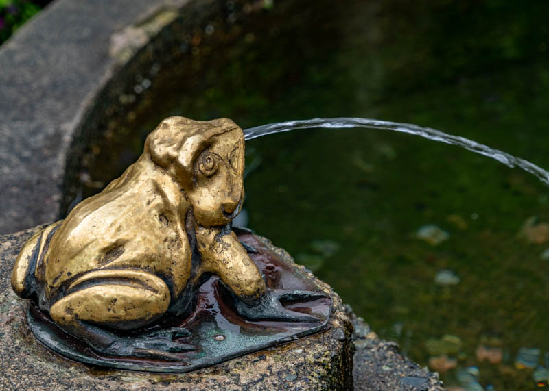
But first, fisherman’s wharf  and the houseboats. 
We were scheduled on Eagle Wings Whales and Wildlife Tours on a large catamaran Wild for Whales.  It had both open and closed areas for the passengers.
As we headed out of the harbor, we passed a Canadian Naval ship heading out for exercises.    A number of these young professionals were staying in our hotel.  When we saw them later in the day, they were surprised that we took their picture.  Now you can’t identify them as I didn’t have that kind of lens, but they were still happy that we cared.
As we sailed out looking for the whales.  Now, why did I say this was different than Alaska?  They were taking us out to see Orcas. Orcas are not migratory.  These are residents.  In Alaska, using you are looking for Humpback whales, which do migrate.

The killer whale or orca  (Orcinus orca) is a toothed whale belonging to the oceanic dolphin family, of which it is the largest member. Killer whales have a diverse diet, although individual populations often specialize in particular types of prey. Some feed exclusively on fish, while others hunt marine mammals such as seals and other species of dolphin. They have been known to attack baleen whale calves, and even adult whales. Killer whales are apex predators, as no animal preys on them. A cosmopolitan species, they can be found in each of the world’s oceans in a variety of marine environments, from Arctic and Antarctic regions to tropical seas, absent only from the Baltic and Black seas, and some areas of the Arctic Ocean.

Killer whales are highly social; some populations are composed of matrilineal  family groups or pods, which are the most stable of any animal species. Their sophisticated hunting techniques and vocal behaviors, which are often specific to a particular group and passed across generations, have been described as manifestations of animal culture.
The killer whale is one of 35 species in the oceanic dolphin family, which first appeared about 11 million years ago. The killer whale lineage probably branched off shortly thereafter.

Resident orca travel in pods made up of several large extended family groups. When several pods travel together these groups can exceed 80 animals. They are extremely vocal compared to Bigg’s (transient) killer whales.  Their diet consists primarily of Chinook salmon, though it can include up to 32 different species of fish. Residents use echolocation to locate their prey; they produce short bursts of clicks that reflect on the environment around them and produce a picture of their surroundings. They can even tell the difference between species of salmon!

Resident killer whales on the BC coast are divided into two groups: the NORTHERN community and the SOUTHERN community. The population of orca that resides in the waters surrounding southern Vancouver Island is made up of three pods: J, K and L pods, and is commonly referred to as the Southern Resident population. These whales frequent the inshore waters of the Pacific Northwest in the summer months, feasting on returning Chinook salmon populations that are running from the Pacific Ocean to the Fraser River to spawn (April-October).

The Southern Residents have been studied for the past 43 years and each individual orca has been identified.  The saddle patch, the white marking behind the dorsal fin, acts like a fingerprint and allows researchers to keep track of their information, including ID numbers (and nicknames), ages, and family relationships.

The three pods that make up the Southern Resident population mate among each other and do not interbreed with the Northern Residents.  I believe they said we saw L79.

So here are some of my images.  I only had a 240 lens and sure could have used an 800. 
We took too long to find this pod of 4, so we didn’t go to look for  Humpback whales.
We did see this Canadian Aircraft carrier as we watched our whale pod. 
Its a big circle as I really couldn’t pinpoint but it was the general area that was pointed out to me on the map.
Then we headed to find some seals, etc. 
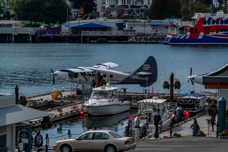
We had expended our time out to sea and now it was time to head back in.  I just loved these little taxi’s.    A sailing ship heading out. And a sea plane taking off.
Some of our group stayed to have lunch on the wharf.  I know I had a wonderful Oyster fishwich.  (Oyster Po boy to me) And it was yum and largest oysters I had seen on this trip.
We then either took a shuttle back to the hotel, or walked back.
Tonight was our farewell dinner to the remaining new friends and our tour director Chan.
And to end this trip – I am including the “family” photos Chan took during our trip.
A final remembrance.
9/2 Cameron Falls, Waterton
9/3 at the Chief Mountain in the distance
9/4 – at the Bellevue underground coal mine
9/9 Bow Lake
  9/10 On a log
  9/11 Whistler Olympic Park
9/11 Whistler hiking group
9/14 at Victoria Thunderbird Park
9/15 at Butchart Gardens

And now it is time to wrap this trip up.  I still owe photos to some people, so I must get those out as I only have a little time left before I head out on another adventure.  This was a great time with some very nice people and a great tour director – Chan Thor.

Victoria – Day 16

I will start this as, this was Carol’s day.  We went to Butchart Gardens.
Coming from Ontario, husband and wife, Robert and Jennie Butchart moved to Vancouver Island to build a cement plant on a rich limestone deposit at Tod Inlet in 1904.  In 1912, as cement production exhausted the limestone deposits, Jennie envisioned a grand garden in its place and began transferring top soil by horse and cart. Little by little, the quarry blossomed into today’s Sunken Garden. Between 1906 and 1929, the Butcharts expanded The Gardens, designing the Japanese Garden on the seaside, the Italian Garden on their former tennis court and the fragrant, overflowing Rose Garden. Gifted The Gardens on his 21st birthday, grandson Ian Ross transformed them into the world-renowned attraction we know today, adding outdoor concerts and night lighting in the summers, and the Magic of Christmas in the winters. Beginning in 1977, great-grandson Christopher began producing a choreographed firework show every year. In 2009, his sister, and current owner of The Gardens, Robin added the Children’s Pavilion and Menagerie Carousel. Two Totem Poles were carved in Classic Coast Salish style by Master Carvers Charles Elliot of the Tsartlip Nation and Doug La Fortune of Tsawout Band, and dedicated on September 9th, 2004 not only to celebrate the 100th anniversary of The Butchart Gardens but also in recognition of the rich cultural heritage provided by Indigenous People.  Today, The Butchart Gardens is a National Historic Site of Canada.
So the following are the images from the gardens.  I am not including the hundreds of individual flowers, but there are still a ton of images here.  You can jump ahead to Chinatown and other Victoria images below if flowers do not interest you.
Carol Chan and his mom   Mikey

OK I lied, but only a little bit.
OK – I’m hungry and we headed off to Chinatown for Dim Sum.  I haven’t had this since I left California.    Our Restaurant –
Chan’s sister joined and helped order for us.  So we got to meet these two important ladies in his life.    It was our pleasure.
Then a walk through China town and down to the wharf area on our own.  Chan walked Carol back to the hotel, so I could go explore.  Thanks Chan.
Fan tan alley.
And though she wasn’t with me on this trip – this is for Becky.


Bastion Square is located in the heart of downtown. The ceremonial entry arch, located at View and Government Streets, welcomes visitors to the original site of old Fort Victoria. The square looks out on the Inner Harbor and boasts some of the finest restaurants, pubs, and cafes in Victoria.
This statue the sailor has a newspaper that declares the end of World War II on his lap.   Celebrating 100 years of the Canadian Navy.
The Empress Hotel   A map showing where we were – Vancouver and where we are Victoria and just across the bay is the USA.

Victoria – Day 15

Today we left Vancouver and some of our newly made friends, as they were flying to their respective homes, and headed to Victoria.  The shuttle took us to Tsawwassen, where we caught the ferry, Spirit of British Columbia.  We carried our suitcases to the ferry where the crew loaded them.   pulling away from the dock –
Next stop was Swartz Bay, Victoria Island.  We gathered our luggage and headed to our new shuttle which was to take us to the Victoria Marriott Inner Harbor.  After we checked into our rooms, Chan had us ready to go for a short circular walk of about a half hour to orient us to the area.  We walked down Humbolt Street to Douglas St.  This was the entrance to the Victoria Conference Center.
with flower baskets everywhere.  We then walked to Thunderbird Park.  Thunderbird Park was established in 1941 when a display of totem poles from the provincial museum’s collection was set up at the corner of Belleville and Douglas streets in Victoria. It is next to the Royal British Columbia Museum.  In 1952, Anthropology Curator Wilson Duff initiated a pole restoration program and hired Kwakwaka’wakw master carver, Mungo Martin, as chief carver for Thunderbird Park.

The park is home to many totem poles (mostly Gitzsan, Haida, and Kwakwaka’wakw) and other First Nation monuments. The park takes its name from the mythological Thunderbird of Indigenous North American cultures which is depicted on many totem poles.

Also in the park are St. Anne’s Schoolhouse (built 1844), Helmcken House, built in 1852, and Mungo Martin House (Wawadit’la), a traditional Kwakwaka’wakw “big house” built in 1953 by Kwakwaka’wakw Chief Mungo Martin. The park is part of the Royal BC Museum Cultural Precinct, an area around the museum that contains a number of historical sites and monuments.

We continued walking towards the harbor passing the Royal British Columbia Museum.  Founded in 1886, the Royal British Columbia Museum  (sometimes referred to as Royal BC Museum) consists of The Province of British Columbia’s natural and human history museum as well as the British Columbia Provincial Archives.  The “Royal” title was approved by Queen Elizabeth II and bestowed by HRH Prince Philip in 1987, to coincide with a Royal tour of that year. The museum merged with the British Columbia Provincial Archives in 2003.  The museum is beside Victoria’s Inner Harbor, between the Empress Hotel and the Legislature Buildings. Just outside the museum is this tower which is a Carillon.

In the Middle Ages, bells became part of Europe’s religious soundscape. Travelling foundry workers cast huge bells on site for the great cathedrals. By the 16th century, the carillon had become a symbol of prosperity and achievement in Flemish and Dutch towns. The sounds of the bells were part of a town’s daily order.

The Netherlands Centennial Carillon was a gift from British Columbia’s Dutch community to honor Canada’s 100th birthday in 1967. It is housed at the top of the tower, which stands 27 90 feet tall.

This carillon, the largest in Canada, has 62 bells. To play, a musician has to climb the 75 steps of the spiral staircase and then a 10-step ladder to sit at the clavier. There, the carilloneur depresses the clavier’s keys and pedals to sound the bells and play a song.

The pitches of several bells commemorate specific events: D celebrates the founding of the Colony of Vancouver Island in 1849, E the founding British Columbia as a colony in 1858, and F-sharp their union in 1866; F rings for the Confederation of Canada in 1867 and G-sharp for British Columbia’s 1871 entry into the Confederation; and G remembers Canadian soldiers who gave their lives for the liberation of the Netherlands, 1940-45.

You will hear the carillon playing automated seasonal themes throughout the Inner Harbor area on the hour between 10 am and 5 pm from October to February and between 10 am and 8 pm from March to September.
Unfortunately, I did not here this one.  I would have enjoyed it as we have one in Florida, at Bok Tower and it is a treat to hear.
Across the road is the Provincial Legislature Building. 
And the war memorial – had WWI and WWII and then Korea and Afganistan wars were added.

Across the street was the harbor  and our little group. 
This is where the group split up and everyone went their own way.  We had the rest of the day to ourselves.
I walked around the harbor a little bit.

Walking passed the Empress Hotel – there was this topiary. 
And a very interesting bicycle rack –   I walked passed a Cool Church – seriously that is its name of website is http://www.coolchurch.ca. 
The Church of Our Lord is a testament to the founding of the Reformed Episcopal Church in Canada, one of the pioneering religious denominations in the City of Victoria. It is notable that this church was founded by Reverend Edward Cridge, the first Bishop of the Reformed Episcopal Church in Canada and an instrumental figure in the city’s religious growth since 1855. Established in 1874 under the auspices of the Church Missionary Society of England, and connected to the Reformed Episcopal Church of the United States, the presence of the Reformed Episcopal Church on the Canadian west coast indicates the early growth of this denomination in North America. Built in 1876, subsequent to a schism of the nearby Anglican Church of England, this church is representative of the early religious diversification of Victoria.
The Church of our Lord is also valued for its atypical architectural style and is the oldest church in Victoria. Designed by architect John Teague, its simplistic vertical lines, steep gable roof, and board-and-batten siding distinguish it from the elaborate masonry churches nearby. The wood form of the Carpenter Gothic style is an excellent example of the adaptation of the classic Gothic style to suit local building materials. In keeping with the beliefs of religious revivals, this style was used for churches across North America.  This freestanding building is one of the few remaining wooden structures of this style and era intact in BC. It is a significant historic landmark on the outskirts of the Old Town District.
Carol was now rested so we went out and walked around before going to dinner.  Here she is on the grounds near the rose garden of the Empress Hotel.
It was starting to drizzle on us so I got Carol back to the hotel and waited until 9 pm  when the weather said would be the least chance of rain and I headed out to see the Legislature building lit up.  But this building caught my eye first. – The Bateman Foundation Gallery of Nature.
The light disappeared and this is how the Provincial Legislature building changed.


Vancouver – Day 14

Sorry for the delay in posting.  The internet in Vancouver and Victoria was less than desired.  I am home now, and apparently ran myself down, and froze on the flight home – so now I am fighting with my sinuses.

This was the last day of the full group.  We started out with a drive to Chinatown.

We stopped to visit Dr Sun Yat-Sen Classical Chinese Garden. Chan made sure we got our steps in as we walked around the entrance a couple of times.  Here Chan is laughing over getting us to the entrance.

The Dr. Sun Yat Sen Classical Chinese Garden is the first Chinese or “scholars” gardenbuilt outside of China, and is located in Chinatown in Vancouver, British Columbia, Canada. It consists of a freely accessible public park and a garden with an admission fee. The mandate of the garden is to “maintain and enhance the bridge of understanding between Chinese and western cultures, promote Chinese culture generally and be an integral part of the local community.”
The garden was built in 1985–1986. The outer park was designed by architects Joe Wai and Donald Vaughan, while the inner garden was conceived by Wang Zu-Xin as the chief architect, with the help of experts from the Landscape Architecture Company of Suzhou, China. It opened on April 24, 1986, in time for Expo 86.

Because the winter climate in Vancouver is similar to that of Suzhou, many of the same plant varieties are found in the garden as in its Suzhou counterparts. The plants were chosen according to their blossom schedules in order to emphasize seasonal changes, especially the “awakening” in spring. They are also selected to invoke the symbolic, historical, and literary meaning of each plant and are used sparingly, in contrast to western gardens, and provide color through all the seasons.

Classical Chinese gardens employ philosophical principles of Feng shui and Taoism, striving to achieve harmony and a balance of opposites. Craggy rocks, for example, are juxtaposed against delicate foliage. Water is also an important element of the garden, and the large pond offers stillness, sound, a reflection of the sky, and helps to unify the other elements. Fish and turtles live in the garden and also serve a symbolic purpose. Bats, dragons, and phoenixes are represented in objects throughout the garden. Numerous large rocks are strategically placed and are intended to represent mountains concealing and revealing park elements.

The garden is named in honor of Dr. Sun Yat Sen, a nationalist leader who is considered the “father of modern China.” The attribution is not arbitrary, as it emphasizes his connection with Vancouver. While traveling the world to raise awareness of, and funding for, the Chinese nationalist movement, Sun Yat-Sen stayed in Vancouver on three different occasions for extended periods. At the time, there was a significant presence of Chinese nationalists in British Columbia, who helped finance the Xinhai Revolution that overthrew the Qing Dynasty in 1911. Sun Yat Sen subsequently became the first president of the Republic of China.

Our interpreter explained the yin yang of objects in each of the areas in the gardens, the significance of certain patterns in the walls, and stone floors.  The Yin, or the dark side, is associated with everything hard, negative, cold, wet, and feminine. The Yang, or the light side, is associated with things soft, positive, warm, dry, and masculine. But contrary to the harsh juxtaposition of their appearances, Yin and Yang are not complete opposites.
  This tapestry panel can be viewed from both sides. The detail in the carving of this tabletop.
the interesting pattern in the stone work in the yards in the central area A couple of the window patterns.  We then sat and had some Jasmine Tea and looked at some of the artwork –   This is hard to see but it is a Chinese character done in charcoal, it is on a mirrored surface, the bars are the ceiling beams.  The orange square is the artist’s signature, which would have been a stamp on paper or fabric.
We then headed over to Granville Island Public Market for us to walk around, have lunch, shop or just relax.  painted silos and interesting buildings. Chan without an ice cream  (yet) and Andy. even a pet store.
And what would a public market be without goodies – We were then off to take a False Creek ferry across. and mussels  that were uncovered by the tide – grow up lil guys.
We then headed to Stanley Park which we missed the day before due to rain.  We were able to see the totem park.   
We had some great views from this park.  – One of the oil tankers sitting waiting  –
And the skyline –   And the statue – which was to be like the Mermaid Sculpture in Copenhagen – but the artist did it as a wetsuit instead of a mermaid to avoid copyright infringement.  Girl in a Wetsuit is a life size 1972 bronze sculpture by Elek Imredy of a woman in a wetsuit, located on a rock in the water along the north side of Stanley Park.
We then drove to Prospect Point.  This is a point at the northern tip of  Stanley Park in Vancouver, located on the south side of the First Narrows of Burrard Inlet. The point, which as its name suggests, is a viewpoint, landmark and tourist attraction in Stanley Park and has a restaurant and other facilities, is just west of the Lions Gate Bridge. 
And Andy being good-natured to pose for us in the crack in the tree.
We headed back to our hotel for our farewell dinner to some of the group.

Vancouver – Day 13

Today was the drive to Vancouver.  Last look at the lobby of the Crystal Lodge in Whistler. 
We started in the rain at Whistler and it was still raining when we arrived in Vancouver.   We made one stop – at Shannon Falls.  Shannon Falls Provincial Park is located in British Columbia, 36 miles from Vancouver and 1 1/4 miles south of Squamish along the Sea to Sky Highway. Shannon Falls is the third highest waterfall in British Columbia dropping 1,105 feet. The park covers an area of almost 215 acres. 
So in the rain, we walked up to see the falls –  at first this was all I saw.  But no the trail went higher.   So now picture me holding an umbrella to protect the camera in one hand and the camera in the other.  No tripod, trying to get a clean shot of these falls.  Somehow I kept the camera dry.  Me, only so so.
Gloria and Georgia with the falls – 
Now, we could not have done this trip without our superior driver – Andy. 
Onwards to Vancouver.       As we drove into town, we passed a few pieces of art and here were some things seen.    We drove through a small part of China town. 
With all the rain, we only got to walk a little around Gastown. We looked in a few shops, and then made our way to the steam clock.
Underneath Vancouver, Canada, there runs a series of steam pipes connected to a generating plant at Georgia and Beatty Streets. The system provides heat to most of the downtown core, and provides the steam for the whistles of the Gastown steam clock.
Despite seeming like a remnant of the Victorian era and being located in Vancouver’s “Gastown” (which was the original townsite from which Vancouver grew in the 1870s), the Steam Clock is actually from a hundred years later, built in 1977 by horologist Raymond Saunders and metalwork specialist Doug Smith.
Saunders was hired by Gastown’s local merchants to build the clock as a monument. It also had an alternative purpose: Placed over a steam grate above one of the aforementioned pipes, it kept local homeless from sleeping on the warm spot. The clock is likely only the second steam clock ever constructed, the first having been built by Englishman John Inshaw in 1859, to draw customers to his tavern.
Because Inshaw’s clock was small and very inaccurate as a timekeeper, Saunders had to reinvent the steam clock from scratch. The new clock proved to be finicky and hard to keep running and required additional funds to get it working properly, around $58,000.
Saying the clock is “steam-powered” is a bit of a misnomer, as the clockworks itself is powered by descending weights. The mini-steam engine at the base of the clock case takes up the role of the human “winder” by raising a series of ball weights and delivering the weights to the clock drive train. But the steam engine is connected by a rubber belt to an electric motor hidden from view – much more reliable than steam power.
Every quarter-hour, the two-ton Steam Clock shows off a bit, whistling and shooting steam from its five whistles in its version of the Westminster Chime. On the hour it marks each hour with a toot from each whistle.
There are six other working “Steam” Clocks in the world. The lesson was learned, though – only the whistles are steam and the clockworks are electric.
The clock is a key tourists destination in Vancouver. It’s also the near the start and a finish line of the Gastown Grand Prix, a single-day cycling race.

We were there for noon when it produced its little show. 

https://www.facebook.com/susan.karski/videos/vb.843253303/10157710727688304/?type=2&theater&notif_t=video_processed&notif_id=1568346076943720
And then making our way back for lunch, Georgia graciously posed with both a bear and moose. 
Then lunch at Steamworks Brewing –   There were some interesting beers. 
And a group shot with Andy – (taken by Chan Thor)  After lunch Andy drove us around Stanley Park.  Unfortunately due to the rain we didn’t get to go see the totem display, or other things there.  So we headed to our hotel, hoping the rain might let up.
Fingers crossed for tomorrow.

Whistler – Day 12

Today we spent in Whistler.  Whistler is a town north of Vancouver, British Columbia, that’s home to Whistler Blackcomb, one of the largest ski resorts in North America. Besides skiing and snowboarding, the area offers snowshoeing, tobogganing and ski jumping at the Olympic Park, a venue for the 2010 Vancouver Winter Olympics. The hub of Whistler is a compact, chalet-style pedestrian village at the base of Whistler and Blackcomb mountains.
After breakfast, we did a walk to Squamish Lil’wat Cultural Center.  But first we walk through the Whistler Village.  Our hotel is part of this experience.  The view from my room.    From the outside looking at the rooms in our hotel. 
Chan was explaining the purpose of the totem in the village. 
There are things to look at every direction you look. 
And in 2010 Whistler hosted the winter Olympics.  So of course, there are pieces left to remind you of that fact.  The whole group (minus me of course)  Chan had someone take a photo with his cell phone of everyone (including me).  Here is Carol by the rings.
  Ohio George enjoying a swing. Our walk was about a mile and we arrived at the cultural center.    We had an interpreter that played the drum and got our people out dancing.    We then went into their auditorium to watch a 15 minute movie about the two tribes. 
After the movie he walked us around the center explaining the totems,  how the boats were created from the trees and the different types of boats.    The wool from the animals was woven into blankets which were important to the tribes.  They are learning how to do the weaving as it was done years ago.  Also the basket weaving is being learned.  The decoration on the outside were to identify the family who owned the basket.  
The interpreter then made himself available for questions and let us walk around to look at the different artifacts. 
We then walked back to the village, again with things to see. 
Carol and I stopped at a bakery for a lighter lunch – and then everyone else came to the same place.  Look at some of the offerings.. Yum. 
I walked over to where the lifts for the ski area to see some of the BMX riders going up on the lifts and then riding down.  I believe it was just everyone getting practice runs in before some racing event.
  this is how the bicycles went up for the riders.
Georgia went for a walk around on one of the many trails. 
And Carol was keeping an eye on Bear, Bearbette and Dudley, making sure they got to bed early enough.  No skipping out for these bears.
Need to get their shut-eye, as we are off to Vancouver in the morning.

Jasper – Maligne Lake – Day 9

Our first day of cooler weather and the rain is here.  High today was about 53.  It has been in the 70s for almost all the previous days.  This morning we had free to walk around Jasper or to go horseback riding or white water rafting.  Due to the short amount of time since I shattered my elbow, I didn’t think it would be in my best interest to entertain doing either of those two things.
The decision was to walk around Jasper and do some shopping and to stop at the bakery for something to nibble on during our outing today.
The train station in Jasper. Georgia with another bear statue. Did you know that Jasper is inside the Jasper National Park?

On Saturday, July 16th, 2011 as part of Parks Day and Parks Canada Centennial Celebrations, Jasper National Park along with many Indigenous and non-Indigenous partners pulled together to raise the Two Brothers Totem Pole in Jasper.

It was beautiful, moving, inspirational and historic celebration- a day that brought together more than 15 different regional Indigenous communities in a joyful celebration of their history and culture.

The celebration fused West Coast Haida culture with regional Indigenous traditions and included two pipe ceremonies, a traditional Haida totem pole blessing and carvers dance, a totem pole transfer ceremony, a friendship ceremony, a traditional feast and a round dance.
The finished totem pole is approximately 45 ft tall and is painted in traditional Haida colors of red, black and blue.

And another bear with Georgia.
But not just Georgia. 
The post office And Fire House The Visitor Information Center.
And a building for Gloria and Georgia. And more bears with Georgia. Oh my, Georgia is such a great sport.

The Rocky Mountaineer was in station.

Near the train station was this older engine.

a map of the area.
And now it was time to get on our bus for a trip out to Maligne Canyon. 
I asked the rangers about the caribou, and they said there were only 4 in the area and they were endangered.
We then started to walk a trail in the canyon.

Maligne Canyon is the deepest canyon in Jasper National Park, with a depth of more than 164 ft. at certain points. Hikers of all abilities can explore this incredible natural landmark by crossing six bridges built across various points of the canyon. For those looking for a gentle hike, head over the First and Second bridges. The Second Bridge is the highest point of the canyon, standing more than 164 feet above the water.

Venturing further will take you to the Third Bridge, which is the best location to see a spectacular waterfall and makes for the perfect photo opportunity. For those looking for an extended hike, continue all the way to the Sixth Bridge for endless exploration and more spectacular sights.
Now, I only made one bridge.  This was very steep. But the views were spectacular.           
After our walks, we got back on the bus and headed to Maligne Lake for a cruise out to Spirit Island.
Declared the “Best Boat Cruise in Canada” by 8 million Reader’s Digest subscribers, the Maligne Lake Cruise is an experience like no other. It is a panoramic tour across the crystal waters of magical Maligne Lake, fed by the glaciers of Jasper National Park. Glide past the jagged mountain peaks as we cruise to Spirit Island, a world-famous destination only accessible by boat.

Spirit Island, named by the Stoney Nation indigenous people for the experiences their ancestors had at this place centuries ago, is a tiny grove of trees and pristine nature separated from the mainland by an isthmus. Spirit Island becomes a true island for a few short days during the summer.

The true attraction of Spirit Island is the backdrop: a ring of impressive peaks and glaciers circling the south end of Maligne Lake, and the deep turquoise water color not present at the North end of the lake. A short path forms a loop from the docks to viewing points overlooking Spirit Island. To preserve the area in its natural state, walking onto the island is not permitted.
This is Spirit Island.

And of course Bear, Bearbette and Dudley were along for the ride.  They listened to the safety instructions and knew where the lifejackets were located.
Mel was our Captain.  She was from Quebec, and Carlos was our interpreter and he was from Chile. and our boat –
Chan brought us another treat.  Maple cookie and candy. 
Now it was time for us to head back to Jasper to get dinner and to get ready to head out for our next town tomorrow.  More to see.  More to experience. We are just past half way.

Lake Louise – Day 7

Today we drove up into Banff National Park, to Lake Louise.  We drove by the train station which was used in the movie Doctor Zhivago.

Lake Louise, named Lake of the Little Fishes by the Stoney Nakota First Nations people, is a glacial lake within Banff National Park in Alberta, Canada. It is located 3.1 miles west of the hamlet of Lake Louise and the Trans-Canada Highway. It is known for its turquoise, glacier-fed lake ringed by high peaks and overlooked by a stately chateau. Hiking trails wind up to the Lake Agnes Tea House for bird’s-eye views. There’s a canoe dock in summer, and a skating rink on the frozen lake in winter. The Lake Louise Ski Resort features a wildlife interpretive center at the top of a gondola.
Lake Louise is named after the Princess Louise Caroline Alberta (1848–1939), the fourth daughter of Queen Victoria and the wife of the Marquess of Lorne, who was the Governor General of Canada from 1878 to 1883.

From the parking lot to the lake – there are a number of trails for you to hike or walk.  Georgia made the attempt to walk up to one of the tea houses but since we were limited on time, she turned back.  She did so much better than I would have.  I didn’t try.  I did do the walk around the side of the lake, so that I could take a photo back of the hotel from the lake view. Here is her trail view.   
The view from the steps up to the Hotel Chateau looking back at the lake.
The Hotel Chateau Lake Louise Fairview  (taken from out around the lake.)-

From around the hotel and inside – 

And the gardens around the hotel – Carol was in flower heaven.

Canmore – Banff – Day 6

Sorry for the delay in this post, but I am struggling with internet connections.  Sometimes it works and sometimes it doesn’t.  I gave up last night, so no post for that day until  now.

First let me start out by saying we have had extremely warm weather.  Other than the day we arrived and the morning after when it rained, we have had temps in the 70s and sunshine.  Today was no different when we went for a tour of the town of Banff.  But before we get to Banff, the Three Sisters Peaks are right behind Canmore and our hotel.  And so are the tracks for the Canadian Pacific Railway.  Here was shortly after sunrise the range behind our hotel and the train making its way west. 
Banff is a resort town in the province of Alberta, located within Banff National Park. The peaks of Mt. Rundle and Mt. Cascade, part of the Rocky Mountains, dominate its skyline. On Banff Avenue, the main thoroughfare, boutiques and restaurants mix with château-style hotels and souvenir shops. The surrounding 4,039 square miles of parkland are home to wildlife including elk, big horn sheep, and grizzly bears.
I did say that we are in the Canadian Rockies –

Our first stop was to drive by the Fairmont Banff Springs Hotel.

The Fairmont Banff Springs, formerly and commonly known as the Banff Springs Hotel, is a historic hotel. The entire town including the hotel, is situated in Banff National Park. The hotel overlooks a valley towards Mount Rundle, both of which are situated within the Rocky Mountain mountain range. The hotel is located at an altitude of 4,639 ft.

The hotel opened in 1888 by the Canadian Pacific Railway, as one of the earliest of Canada’s grand railway hotels. The hotel property has undergone several stages of growth and redevelopment.  The original hotel structure was designed by Bruce Price, with another structure completed in 1914. In 1926, a fire destroyed the original structure on the hotel property, although a replacement structure was later completed in 1928. The building was designated as a National Historic Site of Canada in 1988. The hotel property is presently managed by Fairmont Hotels and Resorts.

The Banff Springs Hotel is located on Spray Avenue near the southern boundary of Banff, a resort town within Banff National Park. The hotel property is bounded by roadways and natural waterways. Two roadways bound the hotel to the north, Bow River Avenue, and Rundle River Avenue, while Spray Avenue bounds the hotel from the west. To the east, the hotel property is bounded by the Spray River. The river serves as a tributary for the Bow River, a waterway north of the hotel property. The hotel property sits near the confluence of the two rivers.
Photos to follow from other vantage points.
We then headed over to see Bow Falls.  Not like your typical waterfalls, the Bow Falls is wide and short. You might feel some mist from the waterfalls during the mid-summer due to the high water levels. You can also see the valley that was eroded by glacier activity and the Bow river over the years.

We then took a short drive to Surprise Corner Viewpoint. 
We then took a very short ride to see the Hoodoos.  Hoodoos are basically weather beaten pillars of sandstone and limestone.They are formed by the effects of erosion caused by wind,water and frost.The striking geological formations are popular icons of Alberta’s badlands.The group of stone columns are very beautiful to watch.
And if you look real close you will see a paddle boarder on the Bow River.  Notice the color of the water.  The silt is created when rocks underneath the surface of the ice are grinding from the movement of the glacier. The rock flour is very light and stays suspended in the lake water for a long time. The sunlight that reflects off this rock flour is what gives the lakes their spectacular turquoise blue or green color.
Next stop was to Lake Minnewanka.

Lake Minnewanka is a large glacial lake three miles from the town of Banff. The lake is 13 miles long and 466 feet deep. It is a beautiful spot, popular for picnicking, mountain biking, hiking, canoeing, diving, and snowshoeing.

For over 100 centuries, people have camped and hunted along the original shores of Lake Minnewanka. The indigenous Stoney Nakoda First Nations people called it Minn-waki (Lake of the Spirits) because they respected and feared the lake for its resident spirits. Early European settlers later named it Devil’s Lake.
     from the flower boxes on the way to the dock –
Very, very tall birch trees.

We then drove around the town of Banff and stopped for lunch. Then it was off to the Gondola, for a bird’s eye view of the area.


And there is more….bear claws.
And wildlife – yes, wildlife.  Chipmunks – and a little bigger – Big Horn Sheep and ewes – 
A final look down at Tunnel Mountain and Banff, before heading down the mountain.  We spent the rest of our time walking around Banff.
 
And back to our hotel for dinner and some much needed rest. Carol chose to rest and for me –  this was the first time I had time to go swim (at the hotel). It felt great.  Meanwhile most everyone else went to the wine and cheese party.


Calgary – Day 1 – Arrival

We arrived – me from the east, just before Dorian (the hurricane) was deciding whether to visit or not, and Gloria, Georgia and Carol from the West. (They don’t have hurricanes there).
My flights were basically uneventful. I stopped in Chicago, not to change planes but just to deplane and re-plane because they have to check your passport.  So I walked around a little of Chicago O’Hare airport and found this statue of musicians.   Then it was back on the plane and off to Calgary.

The plane told me we were getting close, but since I was in an aisle seat, I couldn’t see anything.

Meanwhile, Gloria, Georgia and Carol were winging their way up from California and Gloria could see out the window. – Hello Canadian Rockies.  Hello Calgary.
By now I am at the airport, and they had all kinds of signs for me to want to capture.


But I need to get my luggage – and do customs.  Well customs was quick, but waiting on luggage, took a long time, so off I go to find more things to photograph. These lovely hand shaped steel images of birds, and wildlife were by Jeff  DeBoer.


How nice of them to entertain me while I waited, and waited.
OK, now time to get to my shuttle, but wait more statues and signs…
This last one was pretty but I couldn’t get the family to move away from it, so I only got part of it.

Now Calgary has a BIG airport,  I walked and walked and walked.  Shuttle to hotel, we are staying in a Sheraton Suites.  NICE.  It is in the Eau Claire district. About 5 blocks to China town, and 2 blocks to a bridge to the Prince’s Island Park with lots of flowers.  I also heard I should go see Steven’s Ave.
These are only a couple of images as I need to head back to the hotel to await the arrival of the girls.  Checked in, we went for a short walk before our scheduled first walk with our Tour Director Chan.
So are they Moo Girls or Cow Girls.   ???

We walked towards China town, but not too far because the sky had opened up and it rained on us.

We walked with our tour director through a series of walkways.  The downtown core is home to the largest expanse of walkways in North America. The Plus 15 pedestrian bridges stand 15 feet above street level giving its coined name. It accounts for 16 kilometers of a climate-controlled network of walkways.  It took us close to where we decided to go for dinner – Rodney Oyster House.  We left the group there and walked to our dinner.   Yum.  There was even some liquid refreshment – the National drink of Canada – All hail the Caesar and some insanely sweet ice tea with cinnamon were ordered.
We are now tired and wet. But full stomachs and time to rest for tomorrow.  Hopefully with less rain.

nitey nite.